Tupopdan - Pasu Cones - Pasu Cathedrals
Introduction
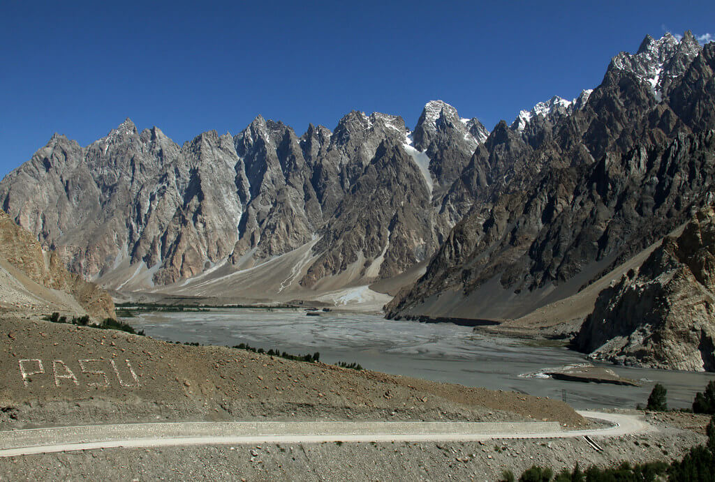
Tupopdan — also popularly known as Passu Cones or Passu Cathedral — is a spectacular mountain peak in the Karakoram range of northern Pakistan. Rising to an elevation of 6,106 m (20,033 ft), it majestically towers over the village of Passu in the Gojal Valley, Gilgit-Baltistan.
Its distinctive sharp, jagged ridges and dramatic shape make it one of the most iconic and photographed mountains in the region.
Name & Meaning
→ The local name Tupopdan is sometimes interpreted to mean “sun-drenched rock” or “hot rock” — implying that snow melts quickly on its sunlit slopes.
→ Another rendering is “sun swallowing mountain,” or “shining rock,” reflecting how its peaks glow dramatically under sunlight or sunset.
→ It is also called Passu Cathedral, linking its form to a grand cathedral spire.
Geography & Topography
→ Range & Subrange
Tupopdan lies in the South Ghujerab Mountains, a subrange of the Karakoram.
→ Location
It is located about 10 km north of Passu village, along the Karakoram Highway corridor through Gojal Valley.
Relief & Faces
→ Its north face alone rises ~1,700 m over a horizontal distance of about 1.5 km, while from the level of the Hunza River, the summit towers about 3,600 m above within around 7 km horizontal distance.
→ Glaciers & Drainage
The slopes of Tupopdan drain into tributaries of the Hunza River. Glacial ice descends from its northern slopes.
Climate
→The climate around Tupopdan is tundra or alpine, characterized by cold winters, snow, and cool summers. Orographic lift causes precipitation (snow/rain) in this high terrain.
History & First Ascent
→ First Ascent
The first recorded ascent was on July 6, 1987, by climbers Andy Cave and John Stevenson, via the Northeast Ridge.
→ Exploration & Local Use
Although the peak is dramatic, it is relatively less frequented in mountaineering compared to more famous Karakoram giants. Many visitors see it from the highway or from nearby viewpoints, rather than climbing it.
Why It’s Famous / Tourist Appeal
→Photography
Because of its dramatic silhouette and serrated ridge line, Tupopdan is among the most photographed peaks in the region.
→Visible from Karakoram Highway
Travelers along the Karakoram Highway often stop to gaze, photograph, and admire Tupopdan — it is one of the signature peaks visible from the road.
→Dramatic Sunlight Effects
At sunrise or late afternoon, the peaks appear to glow or take on deep hues, which adds to the dramatic effect.
→ Cultural / Local Significance
To the local communities, these peaks are part of the natural heritage and visual identity of the Gojal and Hunza region.
Best Vantage Points & Travel Tips
→ Point along Karakoram Highway
Stop at viewpoints along the highway near Passu, where the peaks can be framed with the Hunza River and valley scenery.
→ From Passu Village / Nearby Elevations
Climb elevations near Passu village (or short hills around) to get higher vantage points and unobstructed views.
→ Time of Day & Lighting
Visit during early morning or late afternoon for better light, contrast, and the glowing effect on the peaks.
→ Season
Summer and early autumn months are best, when weather is more stable and access is easier. Winters bring heavy snow and poor visibility.
→ Guides & Permits
Even for viewing or photography, local guides can help you pick the best vantage points and ensure safe walking in mountain terrain.
Climbing & Technical Notes
→ Tupopdan is not among the easiest “tourist climbs” — its sharp ridges, vertical faces, and high altitude pose real challenges.
→ There are few well-documented routes, so technical climbing experience, mountaineering gear, and local expertise are essential.
→ Low traffic means fewer established base camps or support infrastructure.
Conservation & Environment
→ The region is ecologically sensitive. High-altitude flora and fauna, glaciers, and water sources around Tupopdan require protection.
◊ Increased tourism must balance environmental impact — waste management, trail erosion, and disturbance to wildlife are concerns.
→ Climate change may impact snow/glacial cover, altering runoff and local ecosystems.
Related Peaks & Landscape
→ Passu Sar — A neighboring peak visible from Passu village.
→ Batura Glacier — One of the major glaciers in proximity, extending close to the road.
→Shispare and other Karakoram giants** — The broader region hosts many formidable peaks.
Suggested Itinerary / Visit Plan
| Day | Activity |
|---|---|
| Day 1 | Arrive in Gilgit or Hunza region, acclimatize, local sightseeing |
| Day 2 | Travel to Passu village, short hikes, viewpoint visit |
| Day 3 | Sunrise / sunset photo sessions of Tupopdan, local culture & villages |
| Day 4 | Optional trekking / side excursions, depart |
Include local guides, porters if you plan to get into off-trail areas, and buffer days for weather delays.
documented for easy access.
Please contact us for cost and latest updates. Thanks
FAQ (Frequently Asked Questions)
Q: Is Tupopdan the same as Passu Cones?
A: Yes. Tupopdan is the commonly used name, while “Passu Cones” or “Passu Cathedral” are alternate names referencing its cone-shaped peaks.
Q: How high is Tupopdan?
A: 6,106 meters (20,033 feet).
Q: When was it first climbed?
A: On July 6, 1987, by Andy Cave and John Stevenson via the Northeast Ridge.
Q: Is it possible for non-climbers to visit it?
A: Yes — many travelers visit vantage points to photograph and admire it. However, actually summiting requires mountaineering skills, equipment, and local support.
Q: What is the best time to view or photograph it?
A: Late spring to early autumn (May to October) is best. Also, early mornings or late afternoons give dramatic light effects on the peaks.
Q: Where is Tupopdan located?
A: In Gilgit-Baltistan, northern Pakistan, about 10 km north of Passu village, in the Karakoram range.
Q: What should I bring when visiting?
A: Good hiking shoes, warm layered clothing, camera gear, sun protection, local guide/porters, and contingency for altitude and weather changes.
Q: Is there a direct climbing route?
A: Routes exist (e.g. Northeast Ridge as first ascent), but they are technical and not well