Miar Peak Expedition
Rising like a pale pyramid above the sweeping white ribbon of the Miar Glacier, Miar Peak (6,824 m) is one of the Karakoram’s quietly majestic summits, visible from parts of Nagar and along approaches to Rush Lake. Its glacier-carved faces and mirrored sunrise colors on nearby lakes have made it a favorite subject for trekkers and photographers exploring upper Nagar. Wikipedia+1
Quick facts
→ Elevation: 6,824 m (22,388 ft). Wikipedia+1
→ Range: Karakoram (Hispar / Hoper region, Nagar Valley). Wikipedia
→ Nearby features: Miar Glacier, Rush Lake, Rush Peak, Diran, Malubiting. Wikipedia+1
→ Best season to visit: Summer window (June–late July) for trekking and clear views. Mountain Forecast
Geography & geology
Miar Peak stands in the heart of the Karakoram. Its steep, glaciated faces drain into the Miar Glacier system, which connects into the Barpu/Rush valleys. Geologically the region is built of uplifted metamorphic and igneous rocks shaped by the intense tectonics of South-central Asia, producing sharp ridges, icefalls, and glacial troughs characteristic of the Karakoram. Wikipedia+1
Access & trekking routes (overview)
There are two common approach ideas travelers and trekkers use in the area:
01. Gilgit → Nagar → Hoper/Hamder → Miar Glacier corridor
Typical overland travel follows Gilgit to the upper Nagar/Hoper region. Base camps or meadows (Hamder, Dachighan) are used as camping points en route to the Miar Glacier and Rush Lake approaches. Guides and local porters are strongly recommended. Mountain Forecast+1
02. Rush Lake/Rush Peak view-trek
Many trekkers heading to Rush Lake (an alpine lake near Rush Peak) will get dramatic views of Miar Peak and its glacier: the pyramid silhouette of Miar reflects beautifully in lake waters at sunrise and sunset. This is a highly popular high-altitude day/overnight trek for adventurous visitors.
Best time to go
Late June through July gives the most stable weather window for trekking in the upper Karakoram. Outside this window, heavy snow, crevasse instability, and logistics become more difficult. Always check local conditions and hire experienced high-altitude guides. Mountain Forecast
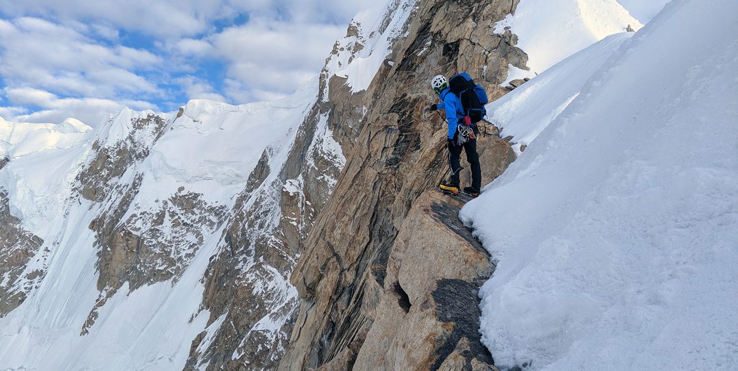
Permits, guides, and safety
→You will generally need permits to travel in restricted high-altitude areas of Gilgit-Baltistan — check with local authorities/tour operators.
→Hire an experienced local guide and trained high-altitude porters. The glacier approach has crevasses and icefall hazards.
→Carry standard high-altitude trekking gear: crampons, rope, stove, warm layers, and an emergency shelter.
→Acclimatize slowly — altitude sickness is a real risk above 3,000–4,000 m.
Photography & viewpoints
→ Rush Lake shore at sunrise — classic reflection shots with Miar in the background.
→ Miar Glacier moraines — foreground texture against Miar’s ice-clad slopes.
→ Use wide lenses for lakescape panoramas and a telephoto to isolate the peak’s ridges.
→ Leave no trace: pack out what you carry in.
→ Respect local communities (Nagar villages) and their cultural sites.
→ Use registered local guides and fair-wage porters to support the mountain economy.
→ Climate change is shrinking Karakoram glaciers in some areas — travel responsibly and support conservation groups working in northern Pakistan. Wikipedia
Suggested 6-day light itinerary (trekker-friendly)
Day 1: Islamabad → Gilgit (flight/drive)
Day 2: Gilgit → Hoper / Nagar (drive, acclimatize)
Day 3: Hoper → Hamder meadows (trek or jeep)
Day 4: Hamder → Dachighan / Miar Glacier approach (camp)
Day 5: Miar Glacier approach → Rush Lake viewpoint (photography, camp)
Day 6: Return to Hoper / Gilgit
(Adjust for extra acclimatization days, weather delays, or if you want to attempt higher objectives.) Mountain Forecast
Please contact for cost and other latest updates etc.
FAQ (concise, user-friendly)
Q: How high is Miar Peak?
A: Miar Peak is about 6,824 meters (22,388 ft) above sea level. Wikipedia+1
Q: Where is Miar Peak located?
A: It lies in the Karakoram range in the Hispar/Hoper area of Nagar Valley, Gilgit-Baltistan, Pakistan. Wikipedia
Q: Can regular trekkers reach viewpoints of Miar Peak?
A: Yes — many trekkers visiting Rush Lake / Rush Peak get excellent distant and mirrored views of Miar Peak. Glacier approaches require glacier travel experience or hiring guides. traversepakistan.com+1
Q: Is Miar Peak climbed often?
A: Miar is not among the mainstream commercial climbs. It has seen attempts and scientific expeditions; some sources describe access as difficult due to glacial barriers. Check the alpine literature and local operators for up-to-date expedition history. Wikipedia+1
Q: When is the best time to visit?
A: Late June to late July is typically the preferred trekking/climbing window for stable conditions. Always confirm with local guides and weather forecasts. Mountain Forecast