Laila Peak (Rupal Valley)
Introduction
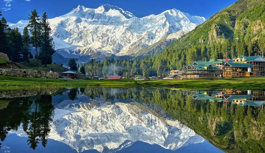
Laila Peak in Rupal Valley is a lesser-known but stunning mountain in the Himalayas of Pakistan. With an elevation of approximately 5,971 meters (19,600 feet), it stands toward the southwestern terminus of Rupal Valley. While overshadowed by its colossal neighbor Nanga Parbat, its distinctive shape, dramatic faces, remote glacial landscapes, and challenging access make it a compelling objective for trekkers and climbers alike. Wikipedia+2AAC Publications+2
Name & Location
→ Name: Laila Peak (Rupal Valley) — “Laila” meaning “beloved” in local lexicons.
→ Location: Southwestern end of Rupal Valley, Astore District, Gilgit-Baltistan, Pakistan. Lies to the right/bottom end of Rupal Valley, visible from parts of the Rupal Glacier and nearby base camps. Wikipedia+2AAC Publications+2
→ Nearby Peaks & Features:
•Rupal Glacier to the north. Wikipedia+1
• Rupal Peak (5,642 m) lies nearby. Wikipedia+1
• A view of the Rupal Face of Nanga Parbat. Guide To Pakistan+2Wikipedia+2
Elevation & Physical Features
→ Elevation: ~ 5,971 meters (some sources list a few variations) above sea level. AAC Publications+2Wikipedia+2
→ Prominence & Terrain: Rupal Valley floor to summit vertical rise is large; steep faces, particularly the south face described as a steep rock wall, and icy, crevassed northern slopes. AAC Publications+2Wikipedia+2
→ Glacial Surroundings: The Rupal Glacier borders the peak. The glacier feed, moraine belts, alpine meadows and glacier-chocked valleys form much of the surrounding terrain. Guide To Pakistan+2AAC Publications+2
History & First Ascent
→ The first recorded ascent was made by a German expedition in 1998. They established their base camp below Mazeno Camp at ~3,950 m and climbed via a route through crevasses to a plateau before onward to the summit. AAC Publications
→ The climb is not very frequently attempted; due to its remote access, technical challenges, and less prominence compared to other peaks in the area. AAC Publications+2Guide To Pakistan+2
Trekking & Climbing Details
→ Access / Trail:
Start usually from Tarashing Village, which is the gateway to Rupal Valley. From there one may trek through lush pastures, moraines, forested areas, then cross glacier or glacier-foreland zones to reach Rupal Glacier and Rupal Base/Advance camps. Guide To Pakistan+1
→ Difficulty:
Steep and mixed terrain (rock + ice + snow), especially on the faces; crevasses, unstable glacier, potential avalanche / rockfall hazards, unpredictable weather. Not suitable for beginners without experience in high-altitude mountaineering.
→ Best Season to Visit / Climb:
Summer to early autumn (May through October) is generally considered best: more stable weather, snow/ice more manageable, trails more accessible. Guide To Pakistan+2beautifulworld.com+2
→ Permits & Regulations:
Since Laila Peak in Rupal is < 6,500 m, many of the stricter permit regimes may not apply (depending on local / regional regulations). But local guidance, checking with Gilgit-Baltistan authorities, and possibly hiring a licensed guide are strongly advised. AAC Publications+2SummitPost+2
Why Laila Peak is Special
→ Striking needle-like summit visible from dramatic glacial and alpine landscapes.
→ Offers views of the Rupal Face of Nanga Parbat, one of the most imposing faces in the Himalayas.
→Less crowded compared to more famous peaks; more solitude, wilderness
→Rich trekking scenery: meadows, glaciers, remote villages, diverse flora (wildflowers, high alpine plants) and possibly wildlife.
How to Get There
| Segment | Route / Information |
|---|---|
| Nearest major city | Gilgit or Skardu (depending on route) |
| Road access | Drive towards Astore via Jaglot off the Karakoram Highway; then progress to Tarashing. Guide To Pakistan+1 |
| Trek starting point | Tarashing Village, then onward to camps along the valley / glacier. |
| Duration | Depending on trek speed, acclimatization, route, often several days of trekking before reaching advanced camps. |
Suggested Itinerary
A sample itinerary for visiting Laila Peak, including trekking and acclimatization:
Culture, Environment & Local Communities
→ Villages: Lower and Upper Rupal villages are small and remote; inhabitants have livelihoods based on pastoralism, small-scale agriculture, local trade. Guide To Pakistan
→ Flora & Fauna: Meadows with wildflowers (edelweiss, forget-me-nots, lavender), forests of willow, poplar; possibly some wildlife typical of high elevations. Guide To Pakistan
→ Environmental Concerns: Glacial retreat, climate change, waste management during trekking, ensuring trails and camps have minimal environmental impact.
Travel Tips & Safety
→ Acclimatize properly to avoid altitude sickness.
→ Hire local guide(s) who know glacier terrain and changing weather.
→ Carry good gear: warm clothing, waterproofs, quality boots, glacier equipment if crossing ice.
→ Be the prepared for sudden weather changes; snow/fog/rain may hamper trail visibility.
→ Respect local customs; stay in local guesthouses or camps, buy supplies locally.
Suggested Itinerary
A sample itinerary for visiting Laila Peak, including trekking and acclimatization:
| Day | Activity |
|---|---|
| Day 1 | Arrive in Islamabad — travel to Gilgit or Skardu |
| Day 2 | Acclimatization / local exploration |
| Day 3 | Drive / transit to Astore → Tarashing Village |
| Day 4 | Trek from Tarashing to first camp / Rupal Village |
| Day 5-6 | Trek further towards Rupal Glacier / Advance Camp |
| Day 7 | Summit attempt (if weather permitting) or rest / acclimatization |
| Day 8 | Descend to base / return through Tarashing |
| Day 9 | Travel back to Gilgit / Skardu / onward journey |
Please contact us for cost and other latest updates
FAQ (Frequently Asked Questions)
Q: What is the exact height of Laila Peak in Rupal Valley?
A: Commonly cited as 5,971 meters, though some sources show slight variations due to mapping or measurement differences. AAC Publications+1
Q: When was Laila Peak first climbed?
A: The first recorded ascent was by a German expedition in 1998. AAC Publications
Q: Is Laila Peak in Rupal Valley the same as Laila Peak in Hushe Valley or Haramosh Valley?
A: No. There are multiple “Laila Peaks” in Pakistan. The Rupal Valley one is distinct, with its own elevation (~ 5,971 m) and geography. Wikipedia+1
Q: Do I need a permit to climb or trek to Laila Peak in Rupal?
A: While it’s < 6,500 m (which in many cases reduces bureaucratic hurdles), you still should check with local authorities, possibly hire a guide, and get necessary permissions especially for restricted or border-adjacent areas.
Q: When is the best time to visit or attempt climbing?
A: Summer to early autumn (May-October) is best. Weather conditions are more stable, trails and glaciers are more navigable. Avoid monsoon or winter seasons due to snowfall and risk.
Q: How difficult is the climb / trek?
A: The route involves glacier travel, crevasses, steep ice/snow/rock faces, altitude. It is challenging; not suitable for beginners. Good fitness, mountaineering experience, and logistical preparation are required.
Q: How remote is the region and what services are available?
A: The region is quite remote: limited infrastructure, few guesthouses, basic food, weak/mobile connectivity in many spots. Bring supplies, plan for emergencies, and rely on local guides.