Ghamubar Zom (6,518m)
Page Content
Introduction
Nestled within the wild folds of the Hindu Raj range — itself tucked between the mightier Hindu Kush and Karakoram ranges — stands the remarkable peak Ghamubar Zom. With an elevation of approximately 6,518 metres, it rises above the glacier-sprinkled valleys of upper Gilgit-Baltistan near the border with Khyber Pakhtunkhwa. en.wikipedia.org+2mapcarta.com+2
Though less famous than some of Pakistan’s 7,000-metre giants, Ghamubar Zom offers a raw, remote mountain experience — high glacial ridges, hushed alpine meadows, and foothills that whisper ancient histories.
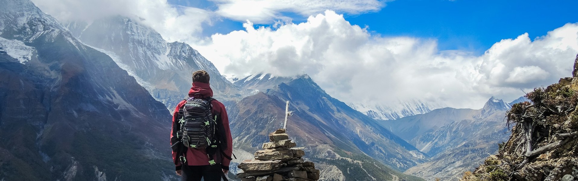
Location & Terrain
Ghamubar Zom is situated in the upper Yasin Valley region of Gilgit-Baltistan, Pakistan. The nearest village is Darkot (also spelled Darkut) in Yasin Valley, from which the peak towers visibly. beautyofpakistan.com+2mapcarta.com+2
Coordinates roughly: 36.5929° N, 73.3416° E. mapcarta.com+1
This region, because of its borderland position and rugged terrain, remains relatively less touched by mass-tourism. The ascent typically involves glacier and snow travel on the upper slopes. mountainblog.it+1
The peak belongs to the Hindu Raj range — a less famous but visually stunning shield of peaks lying between the Hindu Kush and Karakoram. en.wikipedia.org+1
Significance & First Ascents
Ghamubar Zom carries importance for mountaineers seeking less-crowded high peaks. A notable recent first ascent was of the sub-peak “Ghamubar Zom V” (~6,400 m) achieved in alpine style by a Japanese team in 2023 via the north-west ridge. mountainblog.it
Because of its remoteness, technical challenges (glacier, snow, mixed terrain) and relatively low publicity, it offers both challenge and solitude.
Trekking & Climbing Highlights
Elevation: ~6,518 m. Topographic maps
Base Access: The Yasin Valley and Darkot village serve as staging points. One may approach by road/jeep then on foot toward glacier and base-camp.
Route Considerations: Involves glacial moraines, ridges of snow and ice, possibly mixed climbing sections (for the higher summits). The Japanese team noted M5/5.9 sections and steep snow ridges. mountainblog.it
Seasonality: Late summer (July–September) likely offers the best window, when snow conditions moderate and weather is less volatile.
Why Visit: For trekkers and climbers who wish to explore an “undiscovered” high peak, away from mainstream routes; for those who enjoy high-altitude remote valleys, glacier-walks, and high ridge summits.
Local Culture & Environment
The Yasin Valley region is home to hardy mountain communities with traditions rooted in the high-altitude environment. The hillside villages like Darkot are gateways to alpine meadows, lakes, glaciers (e.g., Ghamubar Lake) and dramatic ridges. beautyofpakistan.com+1
The alpine ecology is fragile: glaciers retreating, rocky moraine fields and pristine lakes highlight climate-change impacts. beautyofpakistan.com+1
Travel & Trekking Tips
Acclimatisation: Spend at least a night or two in the valley at moderate altitude before ascending higher.
Guide & Local Support: Hire local guides/porters familiar with the Yasin-Darkot region; they’ll assist in logistics, route finding and culture-sensitive interactions.
Gear: For trekking base-camp access: good boots, waterproof layers, glacier-ready gear (depending on your target). For summit attempt: ropes, crampons, ice-axe, harness and glacier travel competence.
Respect the environment: Carry out all waste; avoid disturbing natural areas; stick to existing trails where possible.
Transport & Access: The roads into Yasin/upper valleys can be rugged; plan for jeep transport and time buffers.
Cultural respect: Local communities may be conservative — dress modestly, ask before photographing people, engage respectfully.
FAQ
Q1: What is the height of Ghamubar Zom?
A1: The summit elevation is recorded at approximately 6,518 metres above sea level. en.wikipedia.org+1
Q2: Where exactly is Ghamubar Zom located?
A2: It is in the Yasin Valley region of Gilgit-Baltistan, Pakistan, in the Hindu Raj range. The nearest village is Darkot (Darkut). beautyofpakistan.com+1
Q3: Is it in the Hindu Kush, Hindu Raj or Karakoram range?
A3: It belongs to the Hindu Raj range, which lies between Hindu Kush and Karakoram. Some sources note border-zone classification relative to Chitral/upper Gilgit regions. en.wikipedia.org+1
Q4: Is it suitable for beginner trekkers?
A4: No — this peak is remote, high (6,500 m+), involves glacier travel and potentially technical climbing. It is more suitable for experienced trekkers/climbers or those supported by seasoned guides.
Q5: What is the best time to plan a trek there?
A5: Late summer months (July to September) typically offer better conditions in this region. Weather is still variable and logistics must factor in remote access.
Q6: How do I access the base of Ghamubar Zom?
A6: You would travel to Yasin Valley (Gilgit-Baltistan) — via roads from Gilgit to Yasin, then onward to Darkot village. From there you trek toward glacier and higher camps. Allow extra days for logistics and acclimatisation.
Q7: What other attractions are nearby?
A7: The region offers wild glaciers, alpine lakes (e.g., Ghamubar Lake), high meadows, and remote valleys. It is less toured, so it provides a more “true wilderness” feel.
12-Day Suggested Itinerary (balanced acclimatisation + summit push option)
Elevations are approximate — adapt daily plan to weather, group fitness and route.
Day 0 — Arrive Gilgit
Arrive Gilgit by flight or road. Final gear check, buy last supplies, meet your local operator or Shimshal/Yasin guide if pre-booked.
Day 1 — Gilgit → Gahkuch → Yasin (Bazaars) → Darkot (jeep)
Drive across scenic highway into upper Ghizer/Yasin, then jeep to Darkot (allow long driving time, rough roads). Overnight Darkot (~2,600–2,700 m / reports vary; local village ~8,500 ft ≈ 2,743 m). beautyofpakistan.com
Day 2 — Rest / village reconnaissance in Darkot (acclimatise)
Meet local porters/guides, explore to nearby meadows and Ghamubar Lake (~2,700–2,900 m depending on site). Short hikes and cultural contacts. beautyofpakistan.com
Day 3 — Darkot → Trailhead → Trek to Lower Camp
Jeep/foot transfer to actual trailhead (river crossings, moraines). Trek 4–6 hrs to lower campsite (3,200–3,600 m). Good overview day.
Day 4 — Lower Camp → Higher Camp (moraine/foot of glacier)
Steady gain across moraines and lateral valley to glacier approaches. Camp near glacier forefield (~3,800–4,200 m). Prepare glacier kit.
Day 5 — Glacier Approach → Advanced Base / BC (ropework practice)
Approach into glacier basin; establish Base Camp (4,200–4,700 m depending on route). Crevasse awareness, rope practice and weather checks.
Day 6 — Rest / Acclimatisation at Base Camp
Rest day — short glacier circuits, fixed rope practice, recon of lower routes. Final summit strategy meeting.
Day 7 — Move to High Camp (if planning summit)
Cache food and fuel; carry lighter loads to high camp (approx 5,000–5,300 m). Prepare summit window.
Day 8 — Summit Push (very early start)
Alpine start pre-dawn. Long technical day with steep snow/ice and possible mixed sections. Summit (if conditions/fitness allow) and descend to high camp / base camp. Note: summit may require ice-axe, crampons, protection for mixed ground. Explorersweb
Day 9 — Contingency / Recovery Day
Weather or rest buffer day. Important on remote expeditions.
Day 10 — Break Camp → Retreat to Lower Camps
Gradual descent across glacier and moraine to lower camps.
Day 11 — Lower Camp → Trek out → Return to Darkot
Finish trek, celebrate with locals, pack for road transit.
Day 12 — Darkot → Drive back to Gilgit → Departure
Return to Gilgit; contingencies for road/flight delays.